Wednesday, June 19, 2013

Vesper Peak, June 9th, 2013

Crossing the S fork of the Stillaguamish was trivial.

 Kevin transitioning to skins, with Wirtz basin in the fog.

 Lower Wirtz Basin and clearing conditions.

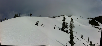
 Upper Wirtz Basin beginning to clear.

Brian booting in upper Wirtz.

 Kevin skinning toward the couloir.

Booting up the couloir.

Looking down the couloir.

 Morning Star Peak from the top of the couloir.

Vesper Peak from the top of the couloir.

The outlet of Lake Elan, with Vesper Peak beyond.

Panorama of Morning Star and Sperry Peaks.

 The Lake Elan basin.

Brian and Kevin enjoying the view of Wirtz Basin.

Wirtz Basin and Sperry Peak, from the road.

Fortune Mt and SE Bowl, May 19th, 2013

 The view of Fortune Mt and the SE Bowl from a trip to Longs Pass in 2011.

The SE Bowl from the entrance.

 Kevin skinning into the bottom of the bowl.

 The view from the bottom of the bowl.


 The access to the south ridge was through these trees.

Kevin, gaining the ridge.

 The view up the ridge.

 Kevin, skinning high on the ridge.

 The view of the bowl from the top of the ridge.

The summit of Fortune.

 Kevin, after dropping in.

The view of east Esmerelda Peak and points south from the halfway point down the bowl.

Saturday, March 9, 2013

Skyline Ridge, Feb 17th, 2013

 The flats just before Skyline Lake.
 Looking at Lichtenberg during a rare clearing from the ridge summit above Moonlight Basin.
 Brian and a splitboarder he hooked up with through TAY. (I can't remember his name.)

 I stopped to take  picture of my line, and Brian poached it.

 Skinning up to Tye Peak after skiing our first run of the day.

 We skied this after lunch.

 Cornices on the final approach to the summit of Tye Peak.

 Brian eating lunch as the high point of the ridge appears out of the clouds.

 Our first run, from the summit of the right-hand summit, down through the trees.

 Our tracks off of Tye Peak.

 Continuing down from Tye Peak.

 Our line down from Tye Peak from the skin track heading back toward Skyline Lake The gladed area dropping down and right from beneath the summit provided 1000 feet of boot top to knee deep powder over a solid crust.

Traversing the final ridge section before dropping into Moonlight Basin.

Moonlight Basin. Three-quarters of this descent was pure fun. The last quarter was skiing styrofoam blocks through narrow corridors between thickets of tight trees. I fell down most of that section.

Thursday, January 24, 2013

Various views of the conditions in the upper Alpental Valley during the Avy 1 class I took  in early January, 2013. The first day was spent in the 'classroom',  and the parking lot. The second day, we went up to the Snow Lake Divide via the summer trail for some frigid (16 degree) beacon work. The final day we toured to Source Lake, and then up to Great Scott Bowl where we dug pits and then engaged in an avy accident scenario (my team found and excavated two victims in less than the survivable 15 minute window!)


On the way up to Snow Lake Divide, looking toward Great Scott Bowl.  The snow strip in the center of the photo was our ascent/descent route the last day.

The view up toward the Snow Lake Divide approach. The Divide was really pretty, but there was a steady blow, and my hands were too cold from beacon practice to take pictures.

Snowshoe hoards descending from Snow Lake Divide. There was a trail runner in shorts and tennies in the mix. That's our instructor Solveig Waterfall in the foreground.

The last day, at Source Lake.

On the ascent to Great Scott Bowl. Solveig setting the skin track.

A brief clearing that allowed a view of Snoqulamie Mt from Great Scott Bowl, at the site where we dug our test pits.

The Tooth during the same clearing, and location.


Sunday, October 28, 2012

Chair Peak Basin, Snoqualmie Pass, August 2nd, 2012


The Great Scott Bowl, and The Tooth, from the trail.

Looking down-valley from the final approach into the basin.

The view from the basin looking east to Mt Snoqualmie and the Cascade Crest peaks beyond.

Looking up into the basin from the rim. The east face of Chair Peak dominates the head of the basin.

 A triptych...
 ...of the rubble-
laden snow in the upper basin.

The basin after lunch, and turns. While I was sitting on the ledge at my high spot below the east face eating my lunch, a woman in her early sixties climbed up and joined me. I noticed she was wearing a 'Little House on the Prairie" bonnet under a bicycling helmet. She asked if I had ever climbed Chair Peak. I responded that I had, a few times. Not having climbed this peak, she asked for advice about the Northeast Buttress route. I told her what I knew as she munched on her sandwich. After she was done, she thanked me and struck out up the ledges to the base of the route. After I took this picture, I looked for her and finally found her making her way up the lower third of the rock buttress that can be seen just left of the dark part of the peak on the right. During our time together I asked her if she had climbed anything else in the area. Her response was, "Most of it."

 The Tooth and Great Scott Bowl from the same spot as the last image.

A panorama of the ridge from Chair Peak to the Tooth.